Search for Oil or Gas Deposit
10 min read
To search for a potential , technicians use techniques to scan the subsurface and produce a 2D or 3D image. Introduced in the 1930s, , which analyzes the signal received from sound waves emitted underground, has become increasingly precise, especially thanks to significant strides in information technology.

© Planète Énergies - A seismic survey vessel tows streamers of ultra-sensitive hydrophones
In most cases, explorers and engineers have regional geological data that give them an initial idea of the oil and gas potential of the area being surveyed. But this data is no longer enough to locate possible deposits, referred to as prospects. Most prospects that can be detected by directly observing the earth’s surface were drilled in the first half of the twentieth century. Today’s prospects are hidden by recent sedimentary deposits whose surface deformations do not provide any hint of what lies deeper beneath the ground. What’s more, the surface cannot be observed in some areas.
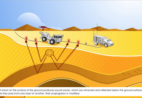
Subsurface Exploration Using Seismic Reflection
To overcome these obstacles, a specific technique known as seismic reflection is used. It was invented in the 1930s and has been continuously improved since then. The seismic data acquisition process is described below:
- First, seismic waves (vibrations) are sent into the ground. They are generated by thumper trucks, which drop a very heavy weight on the ground at regular intervals, or triggered by blasts. , an airgun is used to generate the waves.
- Each time these vibrations encounter a rock layer, some of the seismic waves is reflected like a mirror and bounces back to the surface. The remainder is refracted and continues to travel downwards to lower layers.
- Each time the type of rock changes, the speed at which the wave train propagates changes. Highly sensitive receivers called geophones record the sound waves returning to the surface. Offshore, seismic recording is performed by a vessel towing floating streamers of receivers, called hydrophones. This operation is easier, because there are no natural obstacles to stop the transmitters and receivers from being moved around freely.
The operation is repeated many times, moving the vibration transmitter each time.
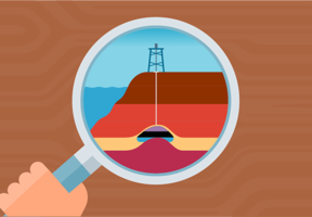
2D, 3D and Even 4D Subsurface Images
The different wave trains captured by the receivers are extremely complex. Tremendous strides in information technology and ever expanding computing are what make it possible to process the data acquired.
- Based on the time it takes the waves to return and assumptions — whose accuracy varies — concerning propagation speeds, two-dimensional (2D) images of the subsurface can be created. They reproduce geological sections and deformations in layers that could potentially form oil or gas traps.
- By acquiring more data, a complete three-dimensional image of the subsurface can be created, one that incorporates volume. This image can sometimes directly detect oil and gas in the geological layers.
- Four-dimension (4D) imaging, which adds in time, is sometimes used on producing deposits. This involves carrying out a number of 3D recordings, several months apart. By comparing these recordings, changes in the deposit can be monitored during production.
Interpretation Issues
However, seismic imaging is an imperfect science and never 100% accurate or reliable.
Soft or uneven ground, very often located at the surface, can disrupt wave trains at source, causing alterations that are difficult to correct for. The deeper the waves travel, the weaker the reflection from each subsequent geological layer. In relatively untapped areas, little is known about the propagation speed and assumptions have not been proved. Lastly, in regions affected by major shifts in the earth’s crust, seismic reflection cannot provide a reliable image of the chaotic subsurface.
This sometimes results in erroneous calculations that can produce false images, just like mirages, and in errors in maps of the subsurface. Only can confirm whether oil or gas is actually present.
 This may interest you
See all


.jpg")


