“Grand Paris” at the Center of the Paris 2024 Olympic and Paralympic Games
10 min read
During the 2024 Olympic and Paralympic Games, with the whole world watching, Paris is undergoing a major transformation. The idea is to create a “Grand Paris”, i.e. an urban area integrating the close suburbs. The entire zone would see its surface area multiplied eightfold, and the population by 3.5.
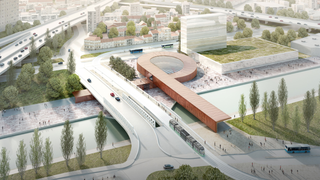
© BIG - Silvio d'Ascia - Four new major metro lines with 68 stations form the backbone of the Grand Paris project. Pictured here is the proposed Pont de Bondy station (architect: Silvio d'Ascia).
The actual city of Paris itself that attracts tourists from all around the world, is very compact and densely populated, with 2.2 million inhabitants living in an area of just 100 km2. An enclosed area of wide boulevards that follow the ancient fortifications, a ring road, and a new circular tramway system reinforce the image of an enclosed city. Paris has always developed in a “star” shape, with its roads and railways radiating out from the city center.
Greater Paris (Grand Paris) will include the City of Paris, the three inner-suburb departments of Seine-Saint-Denis, Hauts-de-Seine and Val-de-Marne and several districts located further on the outskirts. Together they will form an area eight times the size of the historic city of Paris. Even after this expansion, the Paris metropolitan area (814 km2), will still be smaller than Groß Berlin (880 km2) and a far cry from Outer London (1,250 km2). Its population will stand at 7.2 million, and account for 25% of the nation’s wealth.
The Challenge of the Paris 2024 Olympic Games
Paris has naturally brought all its most famous sites into play for the Olympics: the river Seine, stage for the opening ceremony, the Eiffel Tower and the Champs de Mars, the place de la Concorde and the Champs Elysées, the Grand Palais, etc.
Nonetheless the nerve center of the Olympics is located in Saint-Denis, north of Paris, in the most popular department of the Paris region. Just opposite the imposing “Stade de France”, opened in 1998, is the new, ultra-modern Watersports Center, the only sustainably built sports facility for the Paris 2024 Olympics.
The Olympic Village has been set up less than 2 km away, which welcomed the athletes and is a new urban development hub, close to but outside, Paris itself.
The Project Backbone: A New Transit System
An initial revolution in the organization of the Parisian suburbs occurred in the 1960s with the construction of “new towns” like Évry or Marne-la-Vallée, where Disneyland Paris stands. However, the connections between them are not efficient or are connected to Paris city center by saturated communication means.
The centerpiece of the Grand Paris project is a new rapid transit system with four automated lines forming a large beltway around the capital.
It should be completely finalized by 2030.
Dubbed the Grand Paris Express, the system will comprise 68 new stations and over 200 kilometers of both subway and surface tracks. The new routes will alleviate traffic on the existing RER commuter lines that converge in the city center and simplify “suburb-to-suburb” travel (a concept that is likely to be phased out in a less centralized system). The new lines will also relieve traffic congestion from highways and lower the number of cars entering Paris itself. The new rapid transit lines will be interconnected with the existing metro and RER networks and provide faster links to the airports and the La Défense business district.
A Quest for Energy Efficiency
The Grand Paris Express should have a direct impact on energy consumption, by making it easier for commuters to switch from using their cars to public transport systems.
The project also plans to accelerate building insulation and encourage the optimization of district heating. The Île-de-France has over 100 district heating systems, the largest of them being in Paris. The aim is to increase the number of connections and boost the share of renewable energies in the network mix.
To become more energy independent, residential areas can adopt solar energy, closed geothermal (using low-depth sensors) and biomass solutions.
Sources:
